- News
- City News
- varanasi News
- ‘Kashi first in nation to use 3D mapping for planning, devpt’
Trending
‘Kashi first in nation to use 3D mapping for planning, devpt’

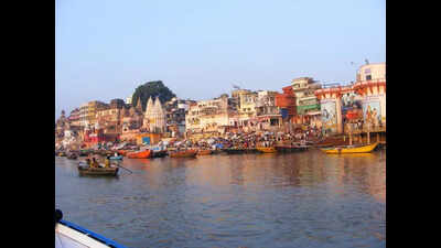
The virtual model of the city Kashi will pave the way for sustainable development. The technology—3D Urban Spatial Digital Twin, will showcase the entire Kashi, including alleys, the Ganga, temples, and key locations of the city. This project, worth around Rs six crore, took nine months to complete.
The 3D Urban Spatial Digital Twin involves cutting-edge Geographical Information System (GIS) solutions, incorporating technologies like Light Detection and Ranging (LiDAR), 360-degree panoramic imagery, and creation of 3D model. Training in this technology is being imparted to the departments to enable its swift implementation.
Chief general manager of Varanasi Smart City D Vasudevan said that Kashi has become the first city in the country where the 3D GIS (360-degree mapping) of a 160 square kilometre area was conducted. The creation of the ‘3D Urban Spatial Digital Twin' of the Varanasi Municipal Corporation area was done using LiDAR technology. This involved over 23 hours of aerial surveys with low-flying aircraft, 1,838 line kilometres by vehicles on roads, and 1,055 line kilometres by backpack walkers in alleys. Drones were also used in this project. This modern technology will also showcase Kashi's heritage, allowing for new development plans.
Project manager Santosh Kumar Tripathi said that the 3D mapping will also be used for real-time response. Cameras will be connected to key locations, allowing for crowd management, crime control, and traffic condition assessments. It will be integrated with existing GIS-based facilities of the VMC, Varanasi Development Authority, and other departments to enhance its utility. It will also aid in waste management, sewage, water management, and more. In case of fire, it will assist in rescue operations, planning for the development authority, preventing illegal construction, monitoring, and issuing NOCs. Additionally, it will provide information on plans related to the tehsil level.
The digital twin will also gather heat-map and thermographic real-time data for congestion management. This initiative enables the municipal corporation to accurately assess and manage property revenues, enhancing revenue collection and urban infrastructure planning.
Meanwhile, the Varanasi Development Authority (VDA) utilises the 3D model to update the Master Plan and issue building permits with greater accuracy and efficiency, promoting planned urban development.
End of Article
Follow Us On Social Media


Photostories

Hot Picks
Top Trending
Explore Every Corner
Across The Globe
UP Board ResultGreen BayDonald TrumpLuka Doncic TradePahalgam Terror AttackBoard Exam ResultDonald TrumpCSK vs SRH Live ScoreIndus Water TreatyBoston Celtics vs Orlando MagicWho is Gabriella ZunigaKhawaja AsifMichael StrahanWWE Smackdown PreviewSethuraman PanchanathanNBA Trade RumorsMichael StrahanNEET UG 2025 Exam City Intimation SlipSimla AgreementUPMSP Board Class 12th ResultWrestlemania 41Student Sevis RecordsJosh AllenWho is Gabriella ZunigaShannon SharpeTravis KelceIPL Purple CapIPL Orange CapIPL Schedule 2025IPL Points Table
Living and Entertainment
Services
Hot on the Web
Health TipsJaat Box Office CollectionKesari 2 Box Office CollectionGood Bad Ugly Box Office CollectionGround Zero Movie Review & Release Live UpdatesPrince Al-WaleedPowerful DrinksGround Zero Box Office CollectionDelhi Bandh NewsRelationship TipsGangers Movie ReviewGround Zero Box Office CollectionGround ZeroMovie ReviewPushups BenefitsParesh RawalPakistan VisaNushrratt BharucchaImanvi IsmailGround Zero Twitter ReviewFawad KhanVisa NewsJunk FoodPakistan Airspace ClosedSrinidhi ShettyFawad KhanManoj BajpayeeR MadhavanLalit ManchandaHina KhanElon MuskPooja BhattBrahmi Tea BenefitsSeema HaiderKaran Veer MehraIndian Cricket Fans TravelIndian Airlines Travel AdvisorySeema SajdehElvish YadavDara SinghSalman KhanAlia BhattVirat Kohli
Trending Topics
Waqf RowDinesh KarthikSRH vs CSKCBSE Class Result DateSukhvinder Singh SukhuIndus Water Treaty SuspensionUPSC CSE Result 2025CR PaatilPahalgam Terror AttackGoogle Work From OfficeDerrick HenrySimla AgreementAleksander Barkov InjuryKash PatelVivian RichardChennai Super Kings vs Sunrisers HyderabadBitan AdhikaryAdil ThokarLargest Economies in The WorldChina Data ProtectionBill GatesNYT Connections HintsNYT StrandsWordle HintsElon MuskPlayStation Plus Removes 22 GamesMohammed ShamiNithin KamathMark ZuckerbergGiannis AntetokounkmpoSantosh JagdaleMS DhoniAniket VermaKamindu MendisFlying Officer Poyla GhoshLuguentz DortTANCET MBA 2025 ResultsCOHSEM Manipur 12th ResultVaibhav SuryavanshiKavya MaranPublic Holidays AprilGarena Free Fire Max Redeem Codes
Popular Categories
HeadlinesSports NewsBusiness NewsIndia NewsWorld NewsBollywood NewsHealth+ TipsIndian TV ShowsTechnologyTravelEtimesHealth & FitnessWWENFLPahalgam Terror AttackAstrologyWeather TodayIPLAnimeApril Bank HolidaysPublic Holidays in AprilIPL TeamsStock Market HolidaysNSE HolidaysBSE HolidaysMCX HolidaysTechnology NewsInternational SportsPublic HolidaysBank Holidays
Latest News
India’s fastest men not included for Asian meetExclusive- Ranveer Singh Malik on Suman Indori going Off Air says, "It was the best experience of my life"EA FC 25 Desire Doue TOTS Honourable Mentions SBC tasks, solutions, and moreHow Ozempic became North America’s go-to weight-loss drugAmit Mishra lambasts Riyan Parag: 'You yourself made mistake, why blame others?'Carlos Alcaraz says he’s not Nadal’s successor: “I want to be known as myself”Elon Musk’s DOGE Tech Support T-shirt is gone, changed to this…Complete List of Weapon IDs in Oblivion RemasteredEducation association files lawsuit to halt unlawful termination of SEVIS records of international students'Terrorism cannot be tolerated': Sourav Ganguly backs severing ties with Pakistan after Pahalgam attackSenior Russian military personnel killed in targeted car bombingJubin Nautiyal on collaborating with Pt Ajoy Chakrabarty for Kesari 2, Akshay Kumar's performance, re-imagining Nusrat Fateh Ali Khan's classic in 'Raid 2' and more - Exclusive'Hunt them down', says US amid support for action by IndiaNo Adrian Newey boost yet at Aston Martin, Fernando Alonso says scoring points is tough this year: “We Need to Get Used to It”Zelensky says may not go to Pope's funeral due to 'military meetings'Misappropriation of funds case: Periyar University V-C appears before Salem policeLewis Hamilton reveals his first karting helmet was stolen, not part of his iconic 400-helmet collection113-million-year-old ‘hell ant’ is the oldest ever found, scientists say
Copyright © 2025 Bennett, Coleman & Co. Ltd. All rights reserved. For reprint rights: Times Syndication Service