- News
- City News
- dehradun News
- Myanmar earthquake triggered 20ft land shift in rare ‘supershear’ event
Trending
Myanmar earthquake triggered 20ft land shift in rare ‘supershear’ event
A massive 7.7 magnitude earthquake near Mandalay, Myanmar, caused a staggering 20ft ground displacement along the Sagaing Fault. NASA and Caltech researchers found the quake triggered a 550km rupture, one of history's longest. The US Geological Survey confirmed right-lateral motion along the India-Eurasia plate boundary.
DEHRADUN: Following the powerful 7.7-magnitude earthquake near Mandalay, Myanmar, on March 28, scientists have confirmed that it caused an extraordinary geological event — there was a horizontal ground displacement of up to 20ft (about 6m) along the Sagaing Fault, a major fault zone where the Indian and Eurasian tectonic plates meet.
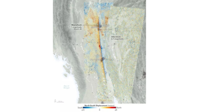
Using data from the European Space Agency's Sentinel-1A and Sentinel-2B/C satellites, researchers from Nasa's Jet Propulsion Laboratory (JPL) and Caltech's Seismological Laboratory have recently found that the quake triggered one of the "longest documented strike-slip fault ruptures in history", spanning 550km from north of Mandalay to south of Nay Pyi Taw, Myanmar's capital. A strike-slip fault involves sideways movement of the ground on either side of the fault.
By comparing images from before and after the earthquake, the Advanced Rapid Imaging and Analysis (ARIA) team estimated significant north-south motion across the fault zone, with some regions experiencing over 9ft (3m) of displacement and total ground offset exceeding 20ft in some places.
The US Geological Survey (USGS) confirmed the quake was caused by right-lateral motion along the India-Eurasia tectonic plate boundary, meaning the land on either side of the fault moved sideways, with the opposite side shifting to the right.
Senior geologist and former director of Uttarakhand's Disaster Mitigation and Management Centre (DMMC) Piyoosh Rautela said, "Ground displacement—also referred to as surface or ground rupture—is a frequent consequence of earthquakes, especially those that are large and shallow. While not all earthquakes produce visible surface movement—particularly smaller or deeper ones—it remains a major hazard linked to more powerful, shallow quakes."
The earthquake, followed by a 6.7-magnitude aftershock 12 minutes later, resulted in more than 3,000 deaths and widespread devastation. Tremors were felt as far as Bangkok, Thailand, nearly 1,000 km away.
This region has a long history of seismic activity, with at least six earthquakes exceeding magnitude 7 recorded within 250km of the March 28 quake since 1900. Scientists warn that the event may signal elevated seismic risks in a region already considered one of the most earthquake-prone zones in Southeast Asia.
They added that the findings help deepen scientific understanding of fault dynamics and highlight the urgent need for enhanced preparedness and monitoring systems in vulnerable regions.
End of Article
Follow Us On Social Media


